J&K Weather to Remain Dry Till End of November, Temperatures Set to Drop Further: MeT

weather

The Jammu and Kashmir Meteorological Department on Wednesday said that the weather will remain dry across the Union Territory until the end of November, with both day and night temperatures expected to drop further in the coming days.Click Here To Follow Our WhatsApp Channel

A MeT official said that the valley has experienced a long dry spell from mid-October till now, with only a brief spell of light rain due to a weak western disturbance earlier this month. “There is no chance of any major weather activity in the coming days. The weather is expected to remain dry till the end of November,” he said.

The official added that the continuing dry conditions will lead to colder days and nights. “There may be a drop in maximum and minimum temperatures. Overall, the weather will remain cold and dry,” he said.

He also said that poor visibility during morning and evening hours may affect road movement in several areas. “People should be cautious, especially during low-visibility hours,” he said.

Issuing an advisory, the MeT department urged children, elderly people, and infants to take extra precautions as temperatures are likely to fall sharply after November 21. “Wear warm clothes and use heating devices to stay safe. The public must also take necessary safety measures to avoid fire-related incidents,” the official said.

The department has advised the public to stay updated with daily forecasts and follow basic winter precautions to stay safe in the coming weeks.(KNS)

Dry Weather Predicted in J&K Till November 3, Light Snowfall Likely on November 4-5

weather

The Meteorological Centre today issued a weather update for Jammu and Kashmir, predicting generally dry weather from October 29th to November 3rd.

A brief spell of light rain and snowfall is expected in isolated areas of Kashmir Division on November 4th and 5th, particularly in the higher reaches.Click Here To Follow Our WhatsApp Channel

Following this, dry weather is expected to return from November 6th to 10th.In light of the forecast, farmers are advised to continue with their farm activities without any disruption.

Light Rain, Snowfall Likely in Higher Reaches; Dry Weather to Prevail Across Jammu and Kashmir

weather

The Meteorological Department has forecast a brief spell of light rain and light snowfall over higher reaches of Jammu and Kashmir on Friday evening, while predicting generally dry weather conditions for the next several days.Click Here To Follow Our WhatsApp Channel

Director Meteorological Department (MET), Dr. Mukhtar Ahmad, as per news agency JKNS said that light rain or snowfall is likely at a few places towards late afternoon or evening today.

He added that the weather is expected to remain generally dry across the Union Territory from October 11 to October 19, with no major weather activity anticipated during this period.

In an advisory, the MET Centre Srinagar urged farmers to continue all agricultural activities as weather conditions are likely to remain favourable for field operations in the coming days.

The department will continue to monitor weather developments and issue updates as needed.

Watch Dr. Tariq Rasool’s Message to Kashmir’s Apple Orchard Owners: Diseases, Causes

A Reflection on Surat-al-Ankabut : Faith, Effort, and the Delusion of Self-Sufficiency

Mehbooba Mufti Criticizes Government for Criminalizing Kashmiris, Condemns Seizure of Geelani’s Widow’s Home

Gulmarg Welcomes Season’s First Snowfall of 2025–26, Thrilling Tourists and Signalling Early Winter in Kashmir

First Snowfall of the Season

The picturesque ski resort of Gulmarg in Jammu and Kashmir woke up to a wintry spectacle on Friday morning as light snowfall dusted its upper reaches overnight, marking the season’s first snow of 2025-2026. The unexpected early winter gift has thrilled tourists and locals alike, while signaling the onset of colder weather across the Kashmir Valley.

The snowfall, which began late Thursday evening and continued into Friday, primarily affected elevations above 2,650 meters, including the iconic Affarwat Peak (3,979 meters) and Sunshine areas. Lower regions of the valley experienced intermittent rain but remained largely dry. Nearby high-altitude destinations like Sonamarg and Gurez Valley also reported fresh snow on their peaks.

Chilly Temperatures and Tourist Delight

Temperatures plummeted across the region, with Gulmarg recording a low of -1°C and Srinagar dipping to 8°C. Eyewitnesses described the scene as “magical,” with social media platforms flooded by photographs and videos of snow-capped meadows transforming the “Meadow of Flowers” into a serene white canvas.

Local tour operator Rehana Begum shared with Grok News, “This early snow is a blessing for us. Tourists are already booking gondola rides to the upper reaches. It’s like nature’s invitation to winter adventures.”

The India Meteorological Department (IMD) had forecasted light to moderate precipitation for higher reaches starting October 5-6, but the event arrived two days ahead of schedule. IMD Director Mukesh Srivastava confirmed, “This is an atypical early onset due to a western disturbance. More significant snowfall is expected from October 5-7, with accumulations of 2-2.5 feet over passes like Sinthan Top, Zojila, and Razdan Top.”

Implications for Tourism and Travel

Gulmarg, Asia’s highest ski destination and a tentative UNESCO World Heritage site, stands to benefit immensely from this prelude to the winter season. Full-fledged skiing typically begins in December, but the early snow has sparked optimism for an extended season. Adventure enthusiasts are flocking to the area for initial snow treks and photography.

However, authorities have issued travel advisories for high passes, warning of potential road blockages and urging motorists to check weather updates. The Jammu and Kashmir Tourism Department advised visitors to “pack warm layers and monitor IMD alerts.”

Regional Weather Forecast

  • October 5-7: Heavy snowfall in upper reaches; possible flurries in Pahalgam, Sonamarg, and Gulmarg.
  • Post-October 7: Dry spell likely, with gradual temperature recovery.
  • Long-term: Kashmir’s winter could see above-average precipitation, boosting water resources but challenging infrastructure.

This early snowfall underscores the unpredictable nature of Himalayan weather patterns, influenced by climate variability. As Gulmarg prepares for its peak tourist influx, the valley braces for a vibrant yet challenging winter ahead.

You Might Also Like:

Former NSG Commando Arrested in Rajasthan with 200 kg of ‘Gaanja’

Mehbooba Mufti Criticizes Government for Criminalizing Kashmiris, Condemns Seizure of Geelani’s Widow’s Home

Mirwaiz Umar Farooq Stresses Justice as Key to Peace, Expresses Solidarity with Palestine and Concern for Kashmir

J&K MeT Issues Adverse Weather Advisory: Heavy Rain, Snowfall and Transport Disruptions Expected October 4–7

weather

 The Meteorological (MeT) Department has issued an adverse weather advisory forecasting rain in the plains and snow in the higher reaches of Jammu and Kashmir and adjoining areas beginning on Saturday.

The advisory, issued on Friday, said that a strong western disturbance is approaching J&K and adjoining areas, under whose effect light to moderate rain in the plains and snow in the higher reaches is likely to occur from October 4 to 7, with peak activity during the night of October 5 to the morning of October 7.

“Under the influence of this western disturbance, moderate to heavy snowfall is likely to occur in Anantnag, Kulgam, Shopian, Zojila Pass, Pir Ki Gali, Razdan Pass, Sinthan Pass and Kupwara-Sadna Pass. Moderate snowfall is likely to occur over the middle reaches. Light to moderate to heavy rainfall is expected in the plains of Kashmir, and isolated heavy to very heavy rainfall over the Jammu region with thunderstorm/lightning/with strong winds with speeds of 40 to 50 kilometres per hour gushing to 60 to 70 Kilometres per hour,” said the MeT Department.

The adverse weather is likely to cause disruption of surface transport on the Jammu-Srinagar national highway, Srinagar-Leh highway and all other roads in the middle and higher reaches of the union territory.

“Chances of landslides, mudslides and shooting stones at vulnerable places. Farmers are advised to suspend all farming activities from 5th to 7th October. Rise in water level in rivers, streams, nallahs and low-lying areas will take place,” the advisory said.

J&K has suffered unprecedented floods in August-September, causing huge devastation, especially in the Jammu division. Huge losses to private and public Infrastructure, roads, buildings and other facilities were caused by those floods.

Agricultural lands in Samba, Jammu, Kathua, and orchards in Kulgam, Shopian, Pulwama and Anantnag suffered heavy damage due to the washing away of chunks of land.

Former NSG Commando Arrested in Rajasthan with 200 kg of ‘Gaanja’

Mehbooba Mufti Criticizes Government for Criminalizing Kashmiris, Condemns Seizure of Geelani’s Widow’s Home

Mirwaiz Umar Farooq Stresses Justice as Key to Peace, Expresses Solidarity with Palestine and Concern for Kashmir

J&K Weather: MeT Predicts First Snowfall on Higher Reaches October 5–6, Warns of Temperature Drop

weather

The Meteorological Centre Srinagar has predicted season’s first snowfall over the higher reaches of Jammu and Kashmir during October 5 and 6, while predicting a significant fall in day temperatures during this period.

As per the forecast, the weather will generally remain dry across J&K till October 4, with the possibility of light rain, thunder and gusty winds towards the late evening or night of October 4.

From October 5 to 7, the MeT said, the weather will turn generally cloudy with intermittent spells of light to moderate rain and thundershowers at many places, along with snowfall over the higher reaches of north, central and south Kashmir, Chenab Valley and important mountain passes like Margan Top and Sinthan Top.

The department cautioned of landslides, mudslides and shooting stones at vulnerable spots during this spell.“A significant fall in day temperatures is expected on October 5 and 6,” the MeT said.

Farmers have been advised to complete paddy harvesting and other horticultural crops and ensure safe storage by October 4 afternoon. Travelers, transporters, tourists and trekkers have also been urged to plan in view of the upcoming weather disturbance.

The weather is expected to improve again with generally dry conditions between October 8 and 10, the MeT added.

Leh Apex Body Halts Talks with Home Ministry Until Normalcy Returns in Ladakh

Kargil Democratic Alliance Demands Release of Sonam Wangchuk, Urges Justice

Former Masjid al-Haram Imam Dr. Sheikh Saleh Al-Talib Released After 7 Years Detention

Baramulla Police File Charge Sheets Against Tehreek-e-Hurriyat, J&K National Front in Unlawful Activities Cases

Jammu Records 190.4 mm Rain, Second-Highest August Downpour in 100 Years; Flood Alert Issued

Jammu Records 190.4 mm Rain

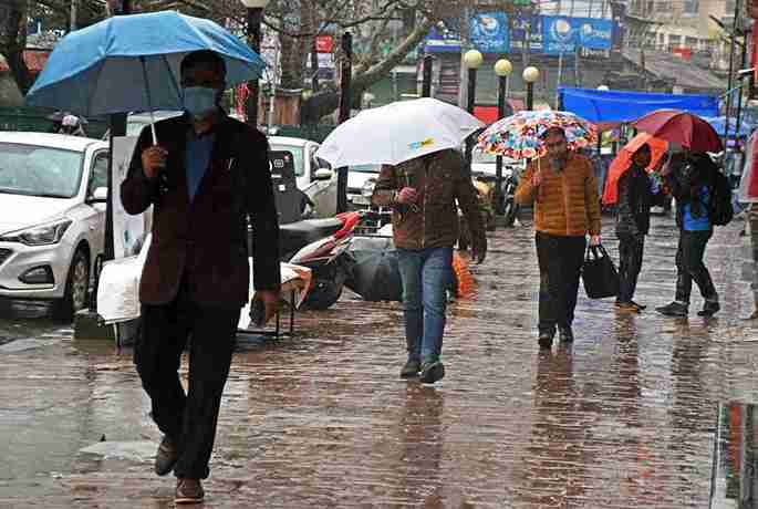
Torrential rains lashed parts of Jammu & Kashmir with Jammu city recording a precipitation of 190.4 mm in the last 24-hours, marking the second-highest August rainfall in nearly 100 years, according to data from Kashmir Weather.

Pertinently, the all-time highest rainfall of 228.6 mm was recorded on August 5, 1926.

The heavy rainfall has led to a flood-like situation in several low-lying areas, with rivers and streams, particularly in Kathua and Samba districts flowing near danger levels.

The Ujh River in Kathua recorded 108,750 cusecs, exceeding the danger mark of 88,000 cusecs, while the Basantar Nallah in Samba crossed its evacuation level of six feet, prompting authorities to issue a flood alert.

According to the news agency—Kashmir News Observer (KNO), low-lying areas like Bhawani Nagar in Janipur and Kabir Colony in Talab Tillo have reported severe waterlogging, with overflowing drains and submerged roads disrupting daily life.

Significant infrastructure damage has been reported, including a critical bridge near Logate Morh on the Jammu–Pathankot National Highway, which was washed away due to the swelling Sahar Khad river.

Meanwhile, the traffic has been diverted to an alternate bridge and the Border Roads Organisation (BRO) has cleared landslides on the Mughal Road to restore the vehicular movement.

However, the Mughal Road and Sinthan Road remained temporarily closed due to ongoing landslide risks.

Notably, the India Meteorological Department (IMD) has issued an orange alert for the Jammu division, forecasting light to moderate rainfall with heavy showers in districts including Anantnag, Kulgam, Doda, Jammu, Kathua, Samba, Kishtwar, Reasi, Ramban, Rajouri, Poonch, and Udhampur until August 26.

Authorities have warned of potential cloudbursts, flash floods, and landslides, urging residents to avoid rivers, streams, and landslide-prone areas.

Furthermore, the Jammu and Kashmir Disaster Management Authority has advised residents to stay vigilant and dial 112 in emergencies.

It is worth mentioning here that Chief Minister Omar Abdullah has directed all departments to remain on high alert, with control rooms actively monitoring the situation.

“Priority is being given to drainage in affected areas and the restoration of essential services like water supply and power,” the post by Officer of J&K CM on X, reads.

“Relief and rescue teams are on standby, and residents in vulnerable areas are urged to identify safer locations in consultation with local authorities.”

Also, the other districts in the Jammu division have also been severely impacted.

Reasi recorded the highest rainfall at 284 mm, followed by Katra (204 mm), Kathua (199 mm), Udhampur (166 mm), Samba (102 mm), and Jammu (160 mm in some areas).

While no casualties have been reported from the latest spell, the region remains on edge following recent tragedies, including a deadly cloudburst in Kishtwar earlier this month.

The administration continues to monitor rising water levels in major rivers and streams, with Deputy Commissioners issuing advisories to avoid water bodies and follow official weather updates.

The public is encouraged to stay cautious as the wet spell is expected to continue over the next 48 hours—(KNO)

Kashmir Politics From Mahraja Hari Singh To Syed Ali Geelani

From Boom to Bust: How the April 22 Terror Attack Shattered Pahalgam’s Tourism Dream

Former Jamat-e-Islami Spokesperson Advocate Zahid Ali Surrenders to Jammu and Kashmir Police

Sajad Lone Slams J&K Government for Taking Over 215 Jamaat e Islami Schools, Calls Move Political Overreach

Fresh Rain Spell Predicted in J&K; MeT Warns of Flash Floods, Landslides, Cloudbursts

weather

The Meteorological Centre Srinagar on Sunday predicted a fresh spell of wet weather across Jammu and Kashmir, cautioning about the risk of flash floods, landslides and cloudbursts in vulnerable areas.

As per the forecast, light to moderate rain and thundershowers are likely at many places between August 24 and 26, with heavy showers expected in parts of Jammu division, particularly Jammu, Reasi, Udhampur, Samba, Kathua and Rajouri. Districts including Poonch, Ramban, Doda, Kishtwar and the southern parts of Kashmir division are also likely to experience moderate to heavy or intense rainfall during this period.

The weather office said that between August 27 and 31, the region may witness hot and humid conditions with brief spells of rain or thunderstorms at isolated places. The same pattern is expected to continue in the first week of September.

The MeT has warned of cloudbursts, flash floods, landslides, mudslides and shooting stones in sensitive areas during the wet spell. People have been advised to stay away from rivers, streams, water bodies, and vulnerable structures, and authorities have been asked to remain alert to tackle any emergency situation

In the Kashmir region, the highest rainfall was recorded at Awantipora with 61.2 mm, followed by Pulwama 37.0 mm, Srinagar Airport 33.2 mm, Kokernag 32.0 mm, and Khudwani 32.0 mm. Other stations with notable rainfall include Gulmarg 30.0 mm, Sangam 29.0 mm, Qazigund 31.2 mm, Pahalgam 21.6 mm, Budgam 21.0 mm, Nowgam Handwara 20.6 mm, Pampore 15.8 mm, and Ganderbal 17.5 mm. Srinagar city recorded 13.5 mm, while other places like Shopian, Verinag, Charar-i-Sharief, Tangmarg, Lolab, Kupwara, and surrounding areas received light to moderate showers.

In the Jammu region, very heavy rainfall was reported from Jammu with 190.4 mm, followed by Jammu Airport 166.0 mm, Udhampur 144.2 mm, and Katra 115.4 mm. Samba recorded 109.0 mm, Chatha 98.5 mm, and Kathua 90.2 mm. Reasi (43.0 mm), Bakore (45.5 mm), Ramban (32.0 mm), Banihal (31.9 mm), and Batote (23.0 mm) had moderate rainfall, while Bhaderwah, Rajouri, and Kishtwar saw lighter showers.

In Ladakh, only light rainfall was reported, with Leh receiving 0.4 mm and Kargil 1.0 mm.

Kashmir Politics From Mahraja Hari Singh To Syed Ali Geelani

From Boom to Bust: How the April 22 Terror Attack Shattered Pahalgam’s Tourism Dream

Former Jamat-e-Islami Spokesperson Advocate Zahid Ali Surrenders to Jammu and Kashmir Police

Sajad Lone Slams J&K Government for Taking Over 215 Jamaat e Islami Schools, Calls Move Political Overreach

IMD Issues Weather Warning for J&K: Heavy Rain, Thunderstorms, Cloudburst Risk from August 17–19

weather

The Meteorological Centre Srinagar on Sunday issued a weather warning for Jammu and Kashmir, forecasting widespread rainfall and thunderstorms from August 17 to 19.

The weather office said light to moderate rain is expected at many places with heavy rainfall likely in parts of Jammu Division, especially Jammu, Reasi, Udhampur, Rajouri, Poonch, Samba and Kathua. Showers of moderate to intense nature are also likely over Doda, Kishtwar and Ramban, while some areas of Kashmir Division may witness brief but strong spells with gusty winds.

From August 20 to 22, the weather is likely to remain hot and humid, though short thundershowers may occur at a few places. A fresh spell of light to moderate rainfall is expected between August 23 and 25 at many places across the Union Territory.

The MET Centre has cautioned of cloudbursts, flash floods, landslides, mudslides and shooting stones during the 17–19 August wet spell.

“People are advised to stay away from streams, Nallas, river embankments and loose structures,” the advisory said, adding that tourists, travellers and transporters should plan accordingly.

Authorities have been asked to remain alert and keep disaster response teams ready to meet any eventuality.

Pahalgam Terror Strike Casts Shadow Over J&K Statehood Demands, Supreme Court Observes

BJP Links J&K Statehood to Elimination of Terror Networks as Supreme Court Reviews Restoration Plea

Kashmiri MBBS Student Saba Rasool Dies in Iran; Family Seeks Urgent Repatriation, Alleging Medical Negligence

Heavy Rains Lash Delhi on Raksha Bandhan, 105 Flights Delayed and City Traffic in Chaos

weather

The national Capital woke up to torrential rain on Saturday, causing widespread waterlogging, traffic snarls, and flight disruptions, marring the festive mood of Raksha Bandhan. According to Flightradar data, at least 105 flights were delayed due to the inclement weather.

Of the delayed flights, 13 were inbound to Delhi’s Indira Gandhi International Airport (IGIA) and 92 were outbound, throwing travel schedules into chaos.Though there were no mass cancellations, airlines and airport authorities issued advisories to caution flyers amid traffic congestion and rain-related delays.

IndiGo and SpiceJet both posted alerts on X, urging passengers to leave early for the airport and keep track of their flight status.Meanwhile, Delhi Airport issued a statement clarifying that operations were largely stable despite the weather.

“As per the Indian Meteorological Department’s forecast, Delhi is experiencing inclement weather conditions. However, all flight operations at Delhi Airport are currently normal. Our on-ground teams are working diligently with all stakeholders to ensure your journey remains hassle-free,” it posted on X.

Rain battered several key areas of the city including Panchkuian Marg, Connaught Place, and Mathura Road, leading to serious waterlogging and gridlocked roads. Commuters faced long delays as several underpasses and arterial roads were inundated.

The India Meteorological Department (IMD) has issued a Red Alert for the entire Delhi region, forecasting moderate to heavy rainfall with the possibility of intense thunderstorms, particularly over East and Central Delhi throughout the day.

While the rain brought a temporary relief from heat and improved air quality, the disruption to daily life and holiday plans was widespread, with many residents taking to social media to share visuals of submerged streets and delayed journeys

CRPF Trooper Dies by Suicide in Anantnag, Police Launch Inquest

Kashmir’s 2025 Food Safety Crackdown: 3,500 kg Rotten Meat Seized

Huma Qureshi’s Cousin Asif Qureshi Murdered in Delhi Parking Dispute, Two Arrested

Kashmir Administration Officially Banned 25 Books including Maulana Maududi’s Al-Jihad fil Islam